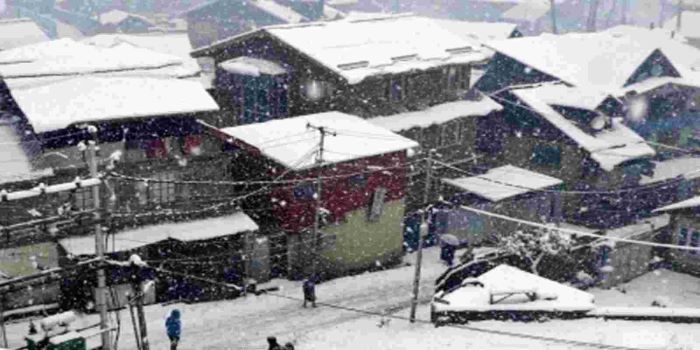
In Jammu and Kashmir, moderate to heavy snowfall occurred in the higher reaches on Thursday, even as the weather office has forecast inclement weather till January 9. Another spell of rain/snow is expected to occur on January 8. Authorities have issued an avalanche warning for the higher reaches and have advised residents of these areas not to leave their homes. Meanwhile, Vehicular traffic on the Srinagar-Jammu highway remained suspended on the second day today due to landslides and shooting stones at several places. Srinagar-Sonamarg-Gumri road and Mughal road also remained shut today due to snow accumulation amid inclement weather conditions across J&K. However, stranded traffic was cleared on Srinagar- Jammu National highway. The flight operations also faced disruptions at the Srinagar Airport due to poor visibility.
The India Meteorological Department (IMD) has predicted a wet spell over northwest India, including Delhi- NCR, Punjab and Haryana, and central India till January 9 due to two consecutive active western disturbances. It, however, said that there may not be cold wave conditions over north India during the next four days. Noting that the minimum temperatures were above normal by 2-5 degree Celsius over most parts of northwest India (excluding Uttar Pradesh), west Madhya Pradesh and Gujarat and near normal over the rest part of north and adjoining central India during the past 24 the IMD said that "no significant change in minimum temperatures" is likely over most parts of north-west India during next 4-5 days. "Gradual rise in minimum temperatures by 2-4 degree celsius is very likely over most parts of central India during next two days and no significance change thereafter for subsequent three days", it said while ruling out the possibility of cold wave conditions in the regions during next five days. The IMD's Thursday bulletin says that s Western Disturbance is likely to move eastwards, deepen further into the Arabian Sea and reach North Pakistan region during next 24 hours. It is likely to persist over North Pakistan region for subsequent 3-4 days.
Referring to the Western disturbance which is very likely to affect North West India from Thursday night onwards, the MET department said, under its influence, an induced cyclonic circulation is very likely to form over South West Rajasthan and neighbourhood on Friday. "High moisture feeding from Arabian Sea is also very likely over North West and Central India during Friday-Saturday. Under its influence, isolated heavy rainfall and snowfall is likely over Jammu & Kashmir, Ladakh, Gilgit, Baltistan, Muzaffarabad on Friday-Saturday and over Himachal Pradesh and Uttarakhand on Saturday", it said.The IMD also predicted the possibility of "isolated heavy rainfall over Punjab and Haryana and Chandigarh on Saturday and isolated thunderstone activity accompanied with hail storms over Madhya Pradesh on Saturday-Sunday, and over Vidarbha on Sunday.


Related Items
India remains engaged with US as Trump proposes Section 301 tariffs
India's services sector growth hits six month high in May
South Korea outpaces India as 6th largest stock market