The defence ministry has said that it completed the survey of 17.78 lakh acres of defence land in the country in a little over three years using modern surveying technologies. The Defence Estates Offices (DEO) records show the MoD owns large tracts of land measuring about 17.99 lakh acres, out of which 1.61 lakh acres is situated within the 62 notified Cantonments. About 16.38 lakh acres is spread across many pockets outside the Cantonments.The magnitude of land holding, location of land in approximately 4,900 pockets across the country, inaccessible terrain in many places and association of various stakeholders makes this survey one of the largest land surveys in the country.
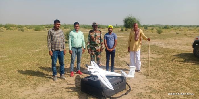
The Directorate General Defence Estates had commenced the Survey of defence land from October 2018. The Ministry said, for the first time after independence, entire defence land has been surveyed by using latest survey technology and in a large number of pockets in association with the Revenue authorities of various State Governments. For the first time, Drone imagery based survey technology was used for survey of lakhs of acres of defence land in Rajasthan. The entire area was surveyed with the help of Surveyor General of India in a matter of weeks, which earlier used to take years. Besides this, Satellite Imagery based survey was done for the first time for many defence land pockets, especially for certain pockets again measuring lakhs acres of defence land. 3D Modelling techniques for better visualisation of defence land in hilly area have also been introduced by utilising Digital Elevation Model (DEM) in association with Bhabha Atomic Research Centre (BARC).


Related Items
West Bengal hands over 142.79 acres land to BSF:Suvendu Adhikari
India, Vietnam discuss defence, maritime security cooperation
BSF to get land for border fencing, WB to adopt BNS, Census circular